

Southern Alberta’s Largest Shopping Centre
January 22, 2021
Mother’s Day Package
January 20, 2022Medicine Hat Landmark Driving Tour
Medicine Hat Landmark Driving Tour
We are excited to launch our Medicine Hat Driving Tour! We created the tour to allow you to enjoy iconic Medicine Hat spots. Thanks to everyone for their great suggestions! We’ve included the GPS coordinates (or click for the Google map directions) and a brief audio description for each stop on the tour.
Don’t forget to share your pictures with us of your favourite spot! @staymedicinehat

Canadian Pacific Railroad Station
The Canadian Pacific Railway Station is a Heritage Railway station that was built in 1906 and expanded in 1911. It is highly valued as a preeminent building associated with the Western expansion of the transcontinental railway building program and the catalyst for the founding of the City of Medicine Hat.
The original route for the CPR proposed by civil engineers avoided Southern Alberta entirely due to the unfavorable farming region. This route was opposed by the CPR and a more southern route was chosen to help manage Canada’s southern border and limit American expansion north. Surveyors first came in 1883 to lay out the railway’s crossing point at the South Saskatchewan River. A camp was established for the route, which would eventually become the City of Medicine Hat. Medicine Hat‘s layout was highly organized with the railway forming the spine of the town and both commercial and residential blocks spreading out words north and south of the tracks. Once established, the railway brought settlers from eastern Canada, the United States and Europe to the prairies. Local businesses established in close proximity to the railway line, provided amenities to residents as well those traveling on from Medicine Hat. The region’s environment coupled with the cities positioning in southern Alberta, vast natural gas deposits and extensive railway network resulted in it becoming a key production and distribution centre in southern Alberta. The City of Medicine Hat’s strong economic base and permanency is reflected in the railway station’s substantial size.
Source: City of Medicine Hat

St.Patrick’s Roman Catholic Church
The St. Patrick’s Roman Catholic Church stands tall with its 170 foot gothic tower, and is said to be one of the finest examples of Gothic Revival architecture in all of North America. Its design was inspired by the medieval cathedrals in Europe.
The construction of the church in 1912, called for challenging and novel building methods and resulted in a triumph of engineering-science for the time. This task required a continuous pouring of concrete, from the bottom of the foundation to the top of the highest cross which was achieved by a large motor-driven concrete mixer connected to a tower elevator. The concrete was hoisted by drum-and-cable and delivered to any part of the wall by large conveyor pipes. In 1912, all of this was achieved without the benefit of modern transit mix or concrete pumps.
In 1932, a false ceiling of wood was installed in the church because of the extraordinary height of the Gothic interior, and consequent heating costs.
The magnificent, round rose windows on the east and west sides of the church were imported from France and were installed as recently as 1955. The new copper roof is part of a restoration program which started 1979, as are the solid oak doors gracing the entry. St. Patrick’s Roman Catholic Church was designated a national historic site of Canada in 1990.
Source: StPatsCatholicChurch.com and Historic Places

Monarch Theatre
The Monarch Theatre is a two-storey Streamline Moderne-style building located in Medicine Hat’s historic downtown. Connected to buildings of similar scale and vintage, the Monarch Theatre is highly valued as the pre-eminent social and entertainment hub and the oldest continuously running purpose-built movie theatre in Medicine Hat. Built in 1911 as a motion picture theatre and amusement house, the first of its kind in Medicine Hat and Canada, the theatre featured a movie auditorium in the west structural bay with a pool and billiards room and tobacco shop in the east structural bay.
The Monarch Theatre, originally designed by a prominent local architect and built by local builders, was the largest and most extravagant theatre in Medicine Hat, exemplifying the growth and sophistication of the city during the Edwardian boom period. The 560-seat theatre opened December 21, 1911, premiering with a Mutt and Jeff film. The original 34 by 78 metre auditorium showed two movies daily with a matinee each afternoon. Initially, silent films were accompanied by a four-piece orchestra, until ‘talkies’ were introduced through the addition of an RCA Photophone in 1929.
Now the historic Monarch Theatre has more than just movies. Their single screen shows new, unique and classic movies. Check their website for upcoming showtimes and events. www.themonarch.net

Five Roses Flour Mill
The Medicine Hat Milling Company, located on what is now South Railway Street, was one of the first industries established in Medicine Hat. The wooden structure opened in 1901, and the company produced bread and cereal. Lake of the Woods Milling Company purchased the operation in 1914 and began producing Five Roses Flour products. This production continued to the mid 1950’s and saw an expansion in 1916 where it was doubled in size and the elevator as it is seen today was built.
The mill was purchased by Ogilvie Flour Company in 1954 and operated for three years before it was closed. It was briefly functional in the 1960s, but for the most part it remained vacant until it was sold in the 1970s. The warehouse was then reduced in size and in 1976 it became the Inn at the Old Mill before becoming the Silver Buckle, with apartments and a pub on the lower floor, as it is seen as today.

Beveridge Building
The Beveridge Building is a prominent two-story building situated on 2nd Ave in Medicine Hat’s historic downtown core. Built in 1911, the building is representative of a period of economic growth in the city prior to the First World War. It is characterized by its classic detailing, size and facade.
Named after longtime Medicine Hat businessman and developer, James Beveridge. He constructed the Beveridge Building to house J. C. Beveridge’s Ltd. Furniture and Men’s Furnishing, as well as a handful of real estate offices. The unique open floor plan of the building set it apart from others at the time. The building’s use shifted in 1986 when the local Salvation Army moved their Family Thrift Store in, using the space until 2009. Following that the business has been owned by a range of businesses and groups. Today, the Beveridge is home to two restaurants, The 1911 Lounge and The Mezz, as well as Heritage Events, an event hosting company.
Source:City of Medicine Hat

Corona Hotel
The Corona Hotel, constructed in 1912, is symbolic of a period of rapid development in Medicine Hat during the Edwardian era, prior to the First World War, and is reflective of the increased demand for short and long-term accommodation during this explosive period of growth. A few intrepid explorers and trappers had traversed the landscape in the late 19th century; however, it was not until the arrival of the railway, that settlement began in earnest. Hotels served as a point of entry for newcomers, providing both short and long-term lodging. The Corona Hotel positioning half a block east of the CPR Station made it highly attractive to settlers arriving to the city. The Corona Hotel, when completed in 1912 by owners William Reid Penland (1875-1946) and William Henry Babb (1850-1912), consisted of 40 hotel rooms, a poolroom, and a café and grille. The same year the hotel permit was obtained, a permit for an addition of an opera house (for theatre and film) and rooms to the east façade of the hotel was acquired; the addition was completed in 1913. Unfortunately, Babb was killed in a car accident in May 1912, preventing him from seeing the completion of the opera house.
It was later, during hotel mogul’s George Cantalini’s ownership, that the Corona Hotel underwent significant alterations, including the opera house being converted to a bowling alley “Bowladrome” in 1941 and the restaurant “Walnut Room” undergoing extensive remodeling in 1958. Today the Corona Hotel and Tavern is a nightclub and bar/lounge with big screen tv’s, pool tables and dance floor.
Source:City of Medicine Hat
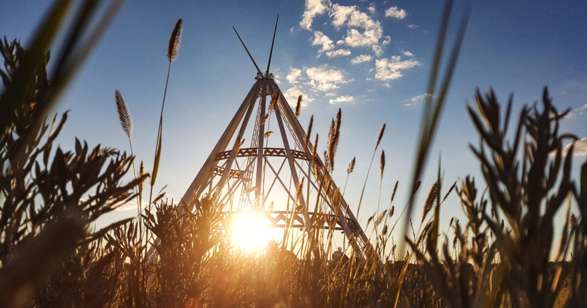
World’s Largest Teepee
Originally constructed for the Calgary 1988 Winter Olympics, the Saamis Tepee is a tribute to Canada’s native heritage. After being moved to Medicine Hat, assembly of the major structural elements began October 20th, 1991, and was completed in less than one week. The World’s Largest Tepee is built entirely of steel with a concrete foundation and is ringed with 10 large circular story-boards depicting aspects of native culture and history. There are ten story-boards built into the tepee depicting native culture and history. The colours of the structure are symbolic, white for purity, red for the rising and setting sun and blue for the flowing river. The Saamis Tepee has a foundation weight of 800 metric tons, and the dead load of the structure is 200 metric tons. The main masts of the Tepee measure 215 feet (equivalent to a 20 story building!) and the diameter of the Tepee is 160 feet. There are 960 bolts holding the Tepee together.
Below the Saamis Tepee in scenic Seven Persons coulee, lays one of the Northern Plains archaeological sites – the Saamis Archaeological Site. The area was once a buffalo camp and meat processing site. Experts believe over 83 million artifacts are buried at the site.

Police Point Park
Beginning as an early Northwest Mounted Police outpost, Police Point Park has many trails and plenty of wildlife. A nature lovers dream there’s over 240 acres of natural reserve. There are many kilometres of walking and cycling trails that wind through cottonwood forests and sagebrush. The Cottonwood “giants” are thought to be between 200 to 300 years old. Visitors might see a porcupine, deer, baby ducks and geese. Exploration begins at the nature centre, open year round, Tuesday through Sunday. The interpretive program is managed by the Medicine Hat Grassland Naturalists, who can direct you around the best kept secrets of the park. The Police Point Park nature centre also offers various displays and public programs such as guided walks and hay rides. Geocaching units, cross country skis and snowshoe rentals are also available.

Ewart Duggan House
The heritage value of the Ewart Duggan Residence lies in its association with some of the earliest and most prominent citizens of Medicine Hat and in its excellent and very rare early example of Victorian residential masonry construction. In 1887, Harry Clinton Yuill built the Ewart-Duggan Residence for Medicine Hat pioneer and influential local businessman John Ewart and his wife, Jessie Herald using bricks produced locally by the McCord brickyard. After the death of Mr. and Mrs. Ewart, their daughter Jacqueline and her husband Hector O. Duggan resided in the home. Like previous residents of the home, the Duggans were significant figures in the community; in addition to trading in real estate and handling investments for international clients, Hector was also a member of a powerful family that included D. M. Duggan, Mayor of Edmonton, and J. J. Duggan, well-known Edmonton entrepreneur and realtor. The home has thus been connected with three of Medicine Hat’s most important families and provides a vital historical link to the founding and development of the city.
This magnificent house stands on Medicine Hat’s historic First Street and is acknowledged as the oldest brick residence in Alberta still on its original foundation built with locally-produced bricks. Overlooking the South Saskatchewan River, this classic two-storey Victorian design remained the Ewart Duggan family home until 1987.
The Province of Alberta designated the house a Provincial Historic Site in 1993, preserving it for future generations to enjoy. In 2002, the house was donated by I-XL Brick Industries to the City of Medicine Hat under the stewardship of the Esplanade Arts and Heritage Centre.
Source: Esplanade Arts and Heritage Centre

Finlay Bridge
Finlay Bridge is a traffic and footbridge crossing the South Saskatchewan River, connecting Riverside and Downtown of Medicine Hat. Constructed of steel, concrete, and wood, this 900-foot span, officially opened on May 14, 1908. Although Medicine Hat’s two banks had been connected by the CPR rail bridge since 1883, as well as a small ferry service originally operated by the Northwest Mounted Police. To use the CPR bridge to travel between downtown and Riverside meant dodging passenger and freight trains. The ferry, although less hazardous, typically only operated for six months of the year. Not only did the bridge instigate development within new areas of the City, but it also solidified Medicine Hat’s establishment as a transportation hub in southeastern Alberta. Finlay Bridge meant that Medicine Hat and Southeast Alberta were truly linked to the rest of the new province of Alberta.
The bridge is named for William T. Finlay: Mayor of Medicine Hat from 1900-1902, a representative for Medicine Hat in the Territorial Government 1902-1905, and Medicine Hat’s first representative in the Alberta Legislature 1905-1910. During his two years as Mayor of Medicine Hat Finlay improved the community’s infrastructure and most significantly secured the municipal ownership of the natural gas resources. It was while serving as the Ministry of Agriculture that he advocated for the construction of a traffic bridge across the South Saskatchewan River to benefit the City’s residents.
Structurally, Finlay Bridge consists of abutments on each bank of the river, 4 concrete piers (40 feet of which are above the bed and 25 feet which are below), and five steel arches (measuring 31 feet in height and are 180 feet long). The bridge as originally constructed was 28 feet wide with a wood deck and a wood sidewalk running along the west side of traffic. A six-foot sidewalk was later added between 1908 and 1917 on the east side of traffic. At the time of construction, Finlay Bridge was the longest steel bridge in Alberta, and the second-longest across the South Saskatchewan when built.
Source: City of Medicine Hat
Echo Dale Park
Echo Dale Regional Park is an oasis for people and wildlife and has more than 110,000 visitors each year. Their patrons range from sun-loving swimmers to those who enjoy sitting around a fire at night, to the regulars who walk the trails each day throughout the year, no matter how bad the weather!
Tour an early settler’s home, or enter the coal mine. Visit the farm animals or just look for the nearby wildlife. There’s a new pirate playground at the swimming lake and don’t forget the boat lake, perfect for a relaxing row. There is also a concession, which sells hot dogs and ice cream. There are shaded BBQ areas too if you bring your own picnic. Walk or bike along the South Saskatchewan River and enjoy the beautiful cliff side views.
From the historic farm site on the west side of the park to the day-use area on the far east side of the park and all the other areas in between, the pristine condition of Echo Dale Regional Park is a local favourite. Pack a bag and plan to enjoy the day at Echo Dale Park!
Admission to Echo Dale Swim Lake is FREE! The swim lake is open from 11 am – 7 pm, seven days a week.
Tour the historic Woolfrey farm house 10am-5pm
For more information, including seasonal hours of operation visit the City of Medicine Hat website.

Red Rock Coulee
Red Rock Coulee is a natural phenomenon in the middle of the prairie. This area contains large red spherical sandstone concretions that have eroded out of the softer bedrock, the best example of spheroid rock formations in Alberta. The reddish boulders are sandstone concretions and are up to 2.5 meters in diameter. They are among the largest in the world. The boulders were formed in prehistoric seas as layers of sand, calcite and iron oxide collected around a nucleus formed by shells, leaves or bones. Look carefully at the concretions- you may be able to see their “growth rings” (layers of sediment deposition) and fossilized shells, leaves or bones. There are eroded steep-sided coulees and a small upland of fescue-needle grass. In places, hoodoos (columns of bedrock) have formed. Plants nearby include gumbo primrose, sagebrush, juniper, prickly pear cactus, prairie crocus, and broomweed. From the ground that feels like popcorn to the unique prairie plants and animals this is a great geological wonder to see.


